In an area east of Orillia and northwest of Lindsay, a flat limestone landscape called the Carden Plain harbours rare habitats known as alvars. Alvars occur only on limestone bedrock with little or no soil, where spring floods and summer droughts create harsh conditions. Many of the wildflowers, native grasses and invertebrate species found on alvars normally occur in the western provinces, and many are rare. These habitats are globally imperiled, occurring only in the south of Sweden and scattered around the Great Lakes Basin. Carden Township’s alvars are thought to be among the richest in the province, with a great diversity of alvar species.
The Carden Plain can be reached from Orillia by way of Sebright, or by Highway 12, then County Road 46, to City of Kawartha Lakes #6. To see this rocky outcrop, and to visit Prairie Smoke (a name given to a property donated to the Nature Conservancy of Canada by Karen Popp), turn north on the west side of Lake Dalrymple, (first turn past the causeway).
The following article has been prepared by Derek Ford, with photos by Heather Ewing and Ulrich Kretschmar. It looks at the geology of the alvar, with pictures of many of the unique features of the area.
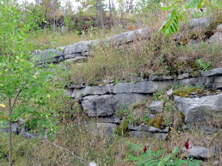
The layers (beds) of rock are normally named after the location where they were first described, or best exposed e.g. here is the ‘Bobcaygeon Formation’ near Bobcaygeon. This dates back to the Ordovician period. It can be recognized by its fossils, which were identified by geologists, and published by the Ontario Geological Survey in the 19th Century. These particular beds are of dolomite (Ca.Mg.2CO3), in contrast to limestone (CaCO3) which is more soluble; a drop of 10% HCl fizzes immediately on limestone, but not on dolomite. The successive Glaciations each scraped off the top meter or two of the beds, so that afterwards the solution processes began anew on fresh rock surfaces.
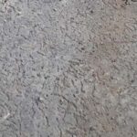
GEOLOGIC SECTION TO DISPLAY ‘EPIKARST’.
This photo illustrates the effects first of steady deposition for a lengthy time on the bed of the Ordovician sea. A thick strong bed, nearly a metre thick, was formed. Then conditions changed to lay down a series of thinner beds above it. These are mechanically weaker and will also dissolve more readily. Typically, each pass of a glacier across such a section removed any weaker top beds of rock, leaving the surface of the underlying thick bed to be attacked by aqueous solution when the vegetation returned. Opened up by solution down any fractures in them, such thick beds form the basis of the ‘epikarst’ (or ‘sub-cutaneous karst’), an uppermost metre or two of the bedrock with highest density of solution voids that drains readily downwards or laterally to springs. While some of the edges of the thin beds are sharp, due to the road cut, most show rounded edges of erosion.
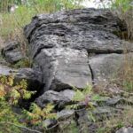
STYLOLITES
A stylolite seam is a highly irregular surface that was created by pressure solution during consolidation of the rock under hundreds or thousands of metres of later accumulation.
This is an example of limestone pavement (the epikarst) in the early stages of development, before the joint fractures have been spread wide open by solution. This particular surface has been scraped clean by a bulldozer, but the same condition will extend on each side of the road, where tree roots are working down into the cracks to increase the rate of solution or, sometimes, wedge an entire block of rock upwards by osmotic pressure.
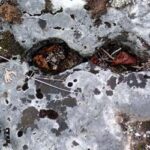
VERMICULATIONS
Vermiculations, or undisturbed worm tracks, were formed when the original limestone was laid down, and they have become more obvious with solutional etching under modern conditions.
The moss is getting a grip into little cavities in the rock. It produces additional CO2 (which causes acidity), which prepares the way for bigger fractures.
CLINTS AND GRIKES
A grike is a vertical fracture (joint) in the bed, caused either by shrinkage of the limestone or by lateral compression (shoved from one side).
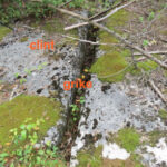
Clints are the undamaged rock surfaces between the grikes, giving the appearance of an array paving stones
This shows a much larger clint surface uninterrupted by grikes. Many patches are like this, with no clint or grike formation, because the underlying limestone bed is exceptionally thick and does not fracture so easily.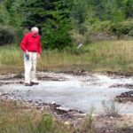
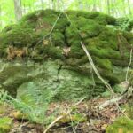
ERATICS
When the glacier scraped most of the surface clean, during recession it dumped ‘glacial erratic blocks’ that it had prised up elsewhere. Some of them have been moved many kilometres. This is an example of a limestone erratic, a local block which probably has not been moved many metres.
This text has been edited and approved by Derek Ford, PhD (Oxford), Professor Emeritus at McMaster University and coauthor of a geology textbook, called Karst Hydrogeology and Geomorphology, published in 2013.
For information on visiting this area, go to The Couchiching Conservancy’s website, scroll to the bottom of the page and click on The Carden Plain. You’ll find maps of the region, brochures and other resources. An ideal time to visit is during the Carden Nature Festival, on Saturday, June 6, 2015. Our expert leaders can teach you about the alvar, the many species that thrive here and a number of the workshops take place on properties that are protected and managed by The Couchiching Conservancy.