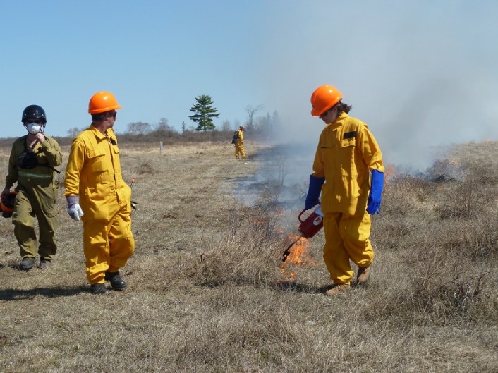
After over 6 years of planning, the Couchiching Conservancy (CC), conducted an experimental prescribed burn on a property on the Cameron Ranch on the Carden Alvar, on April 13th.
Fire is believed to be part of the natural processes of alvars, and has definitely been part of the history in Carden with fires recorded in 1946 and 1881. These large fires however, were not planned and had major impacts on the community at that time.
The burn was classified as a ‘Low Complexity Burn’ because of the limited potential threat of escape and surrounding infrastructure. The burn plot was approximately 10 hectares on the 1,200 hectare property.
The prescribed burn that was conducted on April 13th took into account a number of variables, including moisture level, wind speed and direction, fuel load (mainly dried grasses), humidity levels, vegetation growth and general conditions at the site. The prescribed burn was initially planned for the fall of 2011, however persistent rains prevented the burn from taking place until more favourable conditions were present this spring.
Before the fire, CC staff conducted vegetation surveys to determine the density of the shrubs and the diversity of plant species in the area to be burned. Volunteers from the Toronto Ornithological Club and the Ontario Field Ornithologists have been doing bird monitoring at the burn site for the past four years and will continue this spring to see the impact of the fire on breeding birds. Post-burn vegetation monitoring will also take place.
The location of the burn was chosen in such a way that the fire would impact alvar, grassland and shrubby vegetation communities. The main objectives of the fire was to determine the effects on alvar flowers and grasses, decrease the density of shrubs and to allow managers to become more familiar with how fire will react in this area.
The burn was carried out by Ontario Parks/MNR staff who are trained and experienced in prescribed burning. Before the burn was ignited, a briefing was held to outline all the safety aspects of the burn, use of the equipment and expected fire behaviour. Most staff on the burn were assigned to a suppression role – basically ensuring that the fire remained within the boundaries and did not escape.
Almost 5,000 liters of water was taken from nearby wells to wet down the perimeter of the burn plot, to fill a mobile water tank on the back of an all terrain vehicle, to fill water back packs and to use in the case of an emergency. Volunteer firefighters from the City of Kawartha Lakes were on hand to see the prescribed burn operation.
A path about 3 meters wide was cut last fall to outline the location of the fire and to prevent it from escaping the desired burn plot. Then perimeter of the plot was lit on two sides of the square patch and allowed to burn, creating a buffer about 4 meters wide to further reduce the risk of the fire escaping. Once the perimeter buffer was wide enough and extended from one corner to the next, a centre line was burned diagonally across the centre of the plot. Using the moderate wind conditions, the fire moved towards the corner where it was originally set. Since that area was already burned, the fire would not pass this boundary.
Once the target area was burned, crews went through the area to make sure there were no areas that were smouldering that could flare up once the crews left the site. Although the effects of the prescribed burn won’t be noticeable for a few more weeks, the fire itself was considered to be successful. Throughout the summer, staff will be monitoring the site to develop a better understanding of the impacts of the fire and to determine if another prescribed burn will be an advantageous management strategy in the future.

