With a mission to protect the natural landscapes and wildlife habitats within the region, we employ various strategies to ensure the sustainability and health of these ecosystems. One pivotal method in our conservation toolkit is the use of Ecological Land Classification (ELC).
Understanding Ecological Land Classification
Ecological Land Classification is a scientific method used to categorize the landscape into ecologically meaningful units. This system considers various factors such as soil types, vegetation, topography, and climate to create a comprehensive understanding of different ecological zones. By segmenting the land into distinct ecological units, we can develop targeted strategies for managing and protecting each unique area.
Why ELC Matters for Conservation
The diversity of ecosystems in our region ranges from wetlands and forests to grasslands and aquatic environments, and presents both an opportunity and a challenge. Each ecosystem harbors unique species and plays a specific role in maintaining the ecological balance. The use of ELC allows us to:
Identify Key Habitats: By classifying the land, we can pinpoint critical habitats that are essential for the survival of certain species. This identification is crucial for prioritizing conservation efforts and allocating resources effectively.
Develop Tailored Management Plans: Different ecological units require different management approaches. ELC enables the creation of customized plans that address the specific needs and threats of each unit, whether it’s controlling invasive species, restoring native vegetation, or managing succession to maintain certain unique ecosystems.
Monitor Changes Over Time: ELC provides a baseline for monitoring ecological changes. By comparing current conditions to historical data, we can assess the impact of our conservation efforts and make data-driven adjustments to their strategies.
How does it work?
ELC classification starts with ‘desktop analysis’ which consists of using aerial and satellite imagery to outline different habitat types (these are known as polygons). This can be very coarse to fine detail depending on the quality of the imagery and the size of a property. These general polygons are classified at a high level (deciduous forest, coniferous forest, wetland, rock barren, etc.) with the expectation that they will be refined once they have been ground truthed.
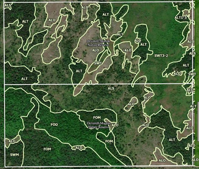
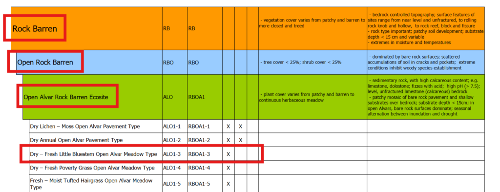
On the ground surveys are used to verify and refine the original polygons, these surveys ideally take place at the right time of year which can vary by habitat. Certain areas are easier to classify in the spring and early summer (ex. Forests) while the spring ephemerals are still blooming, while other areas (ex. alvars, grasslands) have flowers and grasses that bloom in late summer and into the autumn. Each polygon needs to be surveyed on the ground by completing 3 soil samples, 3 prism sweeps (this tells us the composition of tree species), and 3 vegetation plots to find out the dominant species present in the different layers of each plant community (canopy, sub-canopy, understory, ground cover). Each polygon also has an extensive plant list to capture more details about the habitat. Some polygons will need to be split up, or merged with others, depending on what is found during these surveys. To verify and classify to this level of detail each polygon, and therefore the entire property, needs to be walked and surveyed. The amount of time and effort needed changes drastically when you consider some landscapes are very diverse while others can be relatively uniform. Each polygon is then classified to a vegetation type using the Ecological Land Classification for Southern Ontario. As an example, a polygon that gets inundated with water for long periods of time with shallow (under 15cm) to no soils dominated by Little Bluestem, interspersed with Shrubby.
Cinquefoil, Poverty Oat Grass, and Slender Wheat Grass will be classified like this:
Applying ELC in the Couchiching Conservancy
We leverage ELC in several key projects and initiatives:
Land Acquisition and Protection: When considering new lands for acquisition, the Conservancy uses ELC to evaluate the ecological significance of the property. This ensures that their efforts are focused on areas that will have the greatest impact on biodiversity and ecosystem health.
Habitat Restoration: In areas where ecosystems have been degraded, ELC guides the restoration process. For instance, if a wetland has been drained or altered, understanding the specific ecological unit helps in re-establishing native plant species and hydrological conditions.
Species at Risk: Protecting species at risk is a priority for the Conservancy. ELC helps identify habitats that are crucial for these species, allowing for targeted conservation actions such as creating buffer zones, managing human activity, and enhancing habitat connectivity.
Looking Ahead
As environmental challenges continue to evolve, we remain committed to using the best available science to guide our efforts. Ecological Land Classification is more than just a tool—it’s a foundation for understanding and preserving the intricate web of life that defines the natural beauty of our region.
Through the careful application of ELC, we are ensuring each decision made is rooted in a deep understanding of the land, securing the way for a future where nature and people thrive together.
For more information on the Couchiching Conservancy’s work and how you can get involved, visit our website or join us at our next Passport to Nature event. Together, we can make a difference.
Article by: Toby Rowland, Conservation Biologist.