Landscapes
Working with partners over a span of two years, we developed the document Conservation Priorities for The Couchiching Conservancy. It identifies several high-priority zones within the Conservancy’s coverage area. Through this process, it became clear the importance of the Black River Wildlands region and Carden Alvar.
Mapping was done of Species at Risk occurrences, connection to existing protected areas (with land trusts, Conservation Authorities, parks, etc), waterways, forest cover and more. Consideration was also given for highest threats, protections in place, fragmentation and more.
Through that process, we see five key areas for protection:
- Carden Alvar
- Black River Wildlands
- Bass Lake West
- Matchedash Wildlands
- Minesing to Matchedash
Continue scrolling on this page to learn more about these areas!
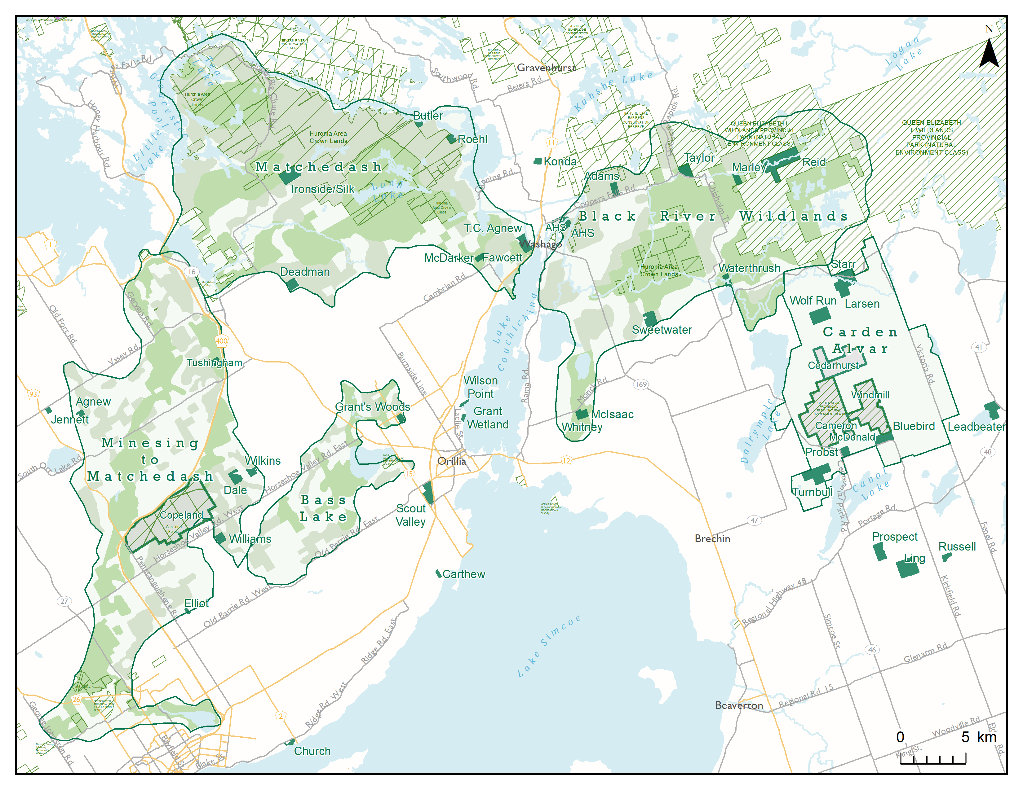
Carden Alvar
In an area east of Orillia and northwest of Lindsay, a flat limestone landscape called the Carden Plain harbours rare habitats known as alvars. Alvars occur only on limestone bedrock with little or no soil, where spring floods and summer droughts create harsh conditions. Many of the wildflowers, native grasses and invertebrate species found on alvars normally occur in the western provinces, and many are rare. These habitats are globally imperiled, occurring only in the south of Sweden and scattered around the Great Lakes Basin. Carden Township’s alvars are thought to be among the richest in the province, with a great diversity of alvar species.
In 1996, The Couchiching Conservancy began a project to identify the locations and extent of these rare habitats. After the alvars were mapped and the vegetation communities and plant species were identified, we shared this information with the landowners and encouraged individuals to ensure long term protection of these unique areas.
Today, over 10,000 acres of land containing alvar habitat has been protected on the Carden Plain through productive partnerships between the Nature Conservancy of Canada, The Couchiching Conservancy, Ontario Parks, Ontario Field Ornithologists, Toronto Ornithological Club, the Carden Field Naturalists and hundreds of volunteers and donors.
For more information on the Carden conservation strategy, download the 2008 report: Towards an Integrated Carden Conservation Strategy Part 1: Healthy Ecosystems & Species at Risk
For more information on the species found on the Carden Plain download this Excel spreadsheet: Carden area species list (Provided by The Nature Conservancy of Canada).
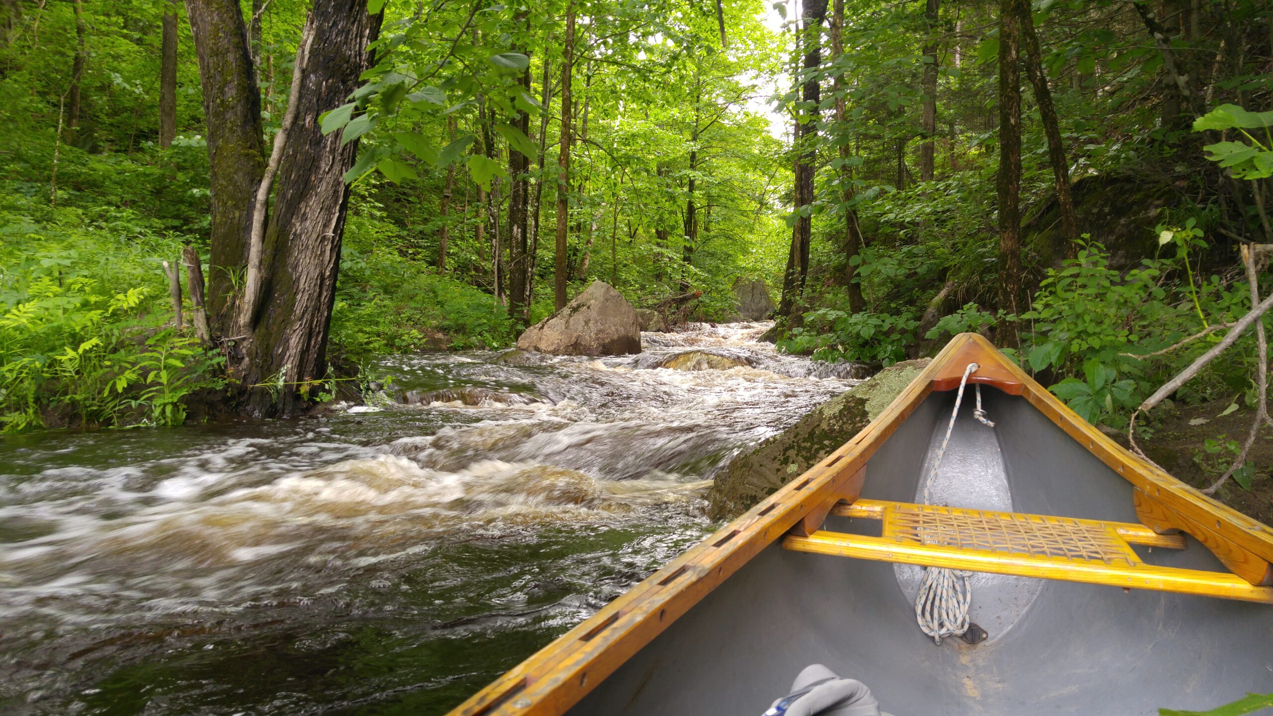
Black River Wildlands
Wetlands are among the richest and most diverse habitats, especially when located along an active river and mixed with drier woodlands. That’s what makes the Black River Wildlands so special. This mosaic of open marshes, majestic soft maple swamps, and coniferous wetlands is interspersed with clay and sand deposits, rock outcrops, and organic soils. This exceptional variety of landforms and vegetation provides habitat for a great diversity of wildlife as well. It is home to Species at Risk, creates natural flood control, connection to other protected areas and more. We first began talking publicly about the Black River Wildlands when we successfully campaigned to protect a 730-acre tract with more than 4 kilometres of river running through it. We named that property The Ron Reid Nature Reserve to honour the lifetime conservation achievements of The Couchiching Conservancy’s first president and executive director. But the Black River Wildlands are so much more than a single property. It was first identified by the Conservancy as an area of interest in 1994 and The Heather and Alec Adams Nature Reserve and Alexander Hope Smith Nature Reserves 1 and 2 all fall into the zone. But with the creation of a new natural heritage analysis in 2018, the Black River Wildlands stood out. Teeming with wildlife and containing the right mix of crown land, park land and potential conservation land to facilitate a natural corridor, it has been identified as one of the prime areas of focus for The Couchiching Conservancy over the next 5-10 years. The preservation of this corridor would be one of the southernmost links to a broad swath of wild space that connects Algonquin Park in the north, the Kawartha Lakes and Carden to the south-east and Georgian Bay to the west with Queen Elizabeth II Wildlands Provincial Park as a central node.
Some of that wildlife dependent on BRW is classed as Threatened because their numbers are rapidly shrinking – Canada Warblers that proclaim their nesting territories from thick cover; Wood Thrush whose ethereal song haunts the evening woods; Snapping Turtles that lay their eggs on sandy beaches. Other species find sanctuary in the sizable roadless heart of this area – Moose and Deer, Black Bears and River Otters. These wide-ranging species need large tracts of wildland for at least some parts of their life cycle, and BRW is one of the most southern areas to meet that need.
Throughout it all, the Black River acts as a connecting corridor, joined by the Head River from the south. In spring, the riverside wetlands soak up vast amounts of floodwater, helping to minimize downstream floods. This natural function is more effective and far less costly than artificial dams.
Bass Lake West
The Couchiching Conservancy has identified the Oro Moraine as one of its areas of strategic interest. The Oro Moraine is a prominent natural environment stretching from Highway 400 to Bass Lake, consisting primarily of forests and a few key wetlands. The Moraine was created during the last ice age when huge volumes of silts, sands and gravels were deposited in this area. The Moraine is ecologically important because of the significance of the forest interior habitat, which is key for the wildlife and plants. Along the edge of the Moraine, there are a number of key wetland areas and water drains to Lake Simcoe, Severn Sound and Nottawasaga Bay. Because the moraine has a filtering effect, the water moving through it is thought to be exceptionally clean.
The Oro Moraine is a key area for nature observation, spring wildflowers, hiking, mountain biking. The Ganaraska Trail cuts through the whole length of the moraine and provides many hiking and nature observation opportunities.
In addition to accepting donations of land in this area, the Conservancy encourages protection of the Oro Moraine through private stewardship activities, conservation easements and land management. The Conservancy also led a community stewardship program in the Copeland Forest and assisted in the formation of the Copeland Forest Friends.
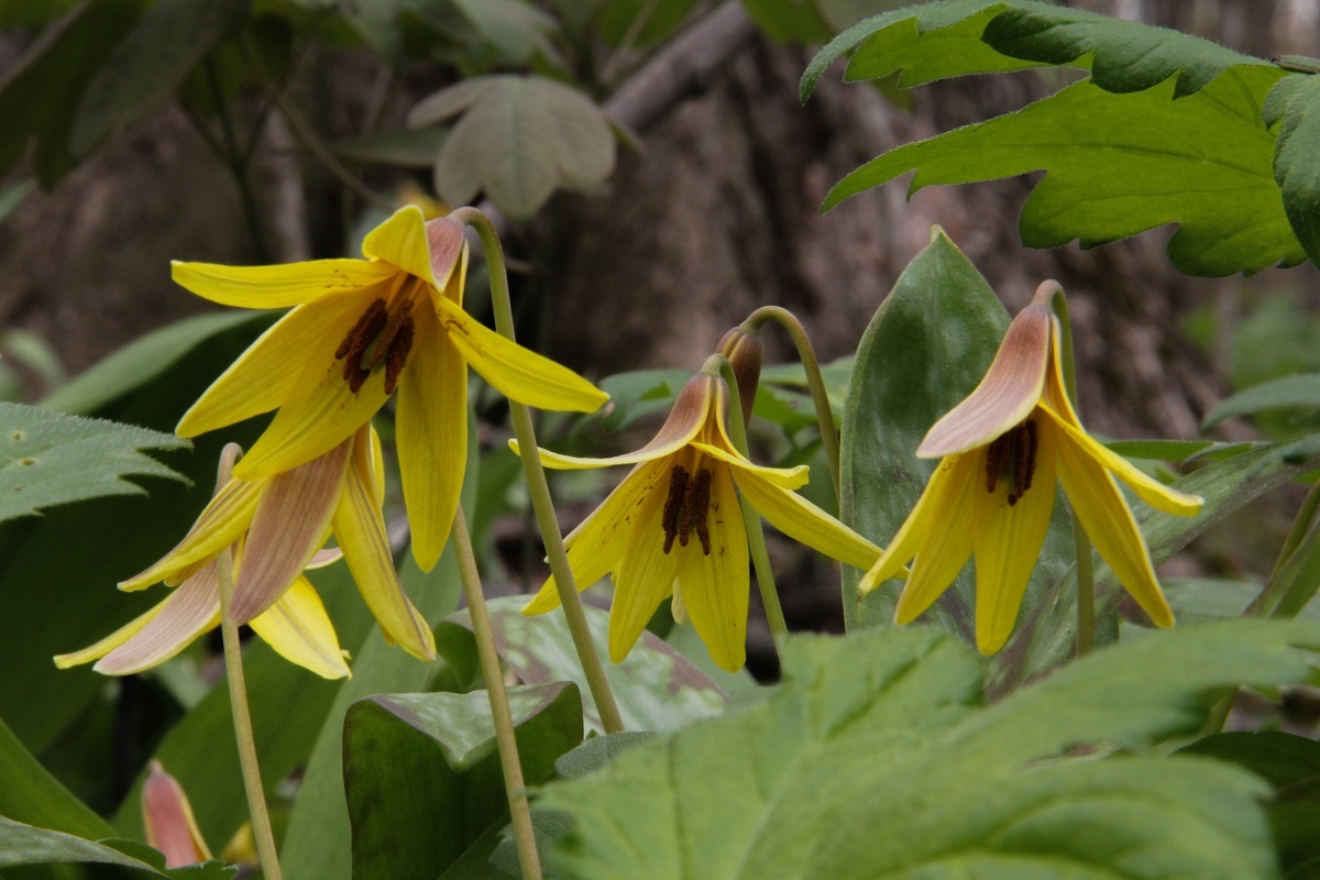
Trout Lillies at Church Woods. G. Church.
Matchedash Wildlands
This corridor connects Minesing Wetlands, a core protected area that is mostly in conservation ownership, to Matchedash Bay Wetlands, another well-established protected area just north of Coldwater. The southern section of this corridor incorporates lands of high conservation value along Willow Creek, including the short tributary from Little Lake in Barrie, and Matheson Creek linking northward to Copeland Forest. The corridor encompasses the western end of the Oro Moraine, which acts as a headwater and recharge area for both Matheson Creek and streams to the north.
Natural values:
- Ecological connectivity along watercourses and valleylands, providing close to continuous habitat connections to allow the northward spread of species in response to climate change. This corridor provides a key linkage for species adaptation on a continent-wide scale, by providing opportunities for movement in a “pinch point” in the Great Lakes region.
- Extensive areas of wetlands and upland forests, with good potential for habitat restoration to improve connectivity where required.
- Extensive areas which function as groundwater recharge zones, which support headwater areas of coldwater streams of exceptional quality.
- The opportunity to protect and enhance a major species corridor of close to 2 kilometers in width in most places, to provide effective linkage between existing major protected areas.
Minesing to Matchedash
This corridor connects Minesing Wetlands, a core protected area that is mostly in conservation ownership, to Matchedash Bay Wetlands, another well-established protected area just north of Coldwater. The southern section of this corridor incorporates lands of high conservation value along Willow Creek, including the short tributary from Little Lake in Barrie, and Matheson Creek linking northward to Copeland Forest. The corridor encompasses the western end of the Oro Moraine, which acts as a headwater and recharge area for both Matheson Creek and streams to the north.
Natural values:
- Ecological connectivity along watercourses and valleylands, providing close to continuous habitat connections to allow the northward spread of species in response to climate change. This corridor provides a key linkage for species adaptation on a continent-wide scale, by providing opportunities for movement in a “pinch point” in the Great Lakes region.
- Extensive areas of wetlands and upland forests, with good potential for habitat restoration to improve connectivity where required.
- Extensive areas which function as groundwater recharge zones, which support headwater areas of coldwater streams of exceptional quality.
- The opportunity to protect and enhance a major species corridor of close to 2 kilometers in width in most places, to provide effective linkage between existing major protected areas.
The Land Between
This corridor connects Minesing Wetlands, a core protected area that is mostly in conservation ownership, to Matchedash Bay Wetlands, another well-established protected area just north of Coldwater. The southern section of this corridor incorporates lands of high conservation value along Willow Creek, including the short tributary from Little Lake in Barrie, and Matheson Creek linking northward to Copeland Forest. The corridor encompasses the western end of the Oro Moraine, which acts as a headwater and recharge area for both Matheson Creek and streams to the north.
Natural values:
- Ecological connectivity along watercourses and valleylands, providing close to continuous habitat connections to allow the northward spread of species in response to climate change. This corridor provides a key linkage for species adaptation on a continent-wide scale, by providing opportunities for movement in a “pinch point” in the Great Lakes region.
- Extensive areas of wetlands and upland forests, with good potential for habitat restoration to improve connectivity where required.
- Extensive areas which function as groundwater recharge zones, which support headwater areas of coldwater streams of exceptional quality.
- The opportunity to protect and enhance a major species corridor of close to 2 kilometers in width in most places, to provide effective linkage between existing major protected areas.